![]()
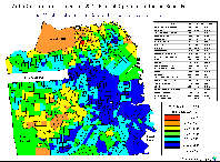
Our expertise with mapping systems, demographics, and geographic information has helped triumphant candidates, political organizations, and research firms. SpatiaLogic's maps are perfect for illustrating voter opinions & competitors' status, and pinpointing specific voting populations. |
 |
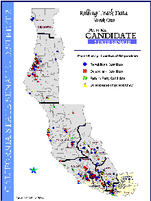 |
Targeting undecided (and unregistered) voters is crucial during an election for building political party support. A common method for generating favorable ballots and registering new voters is Door-to-Door Campaigning. If not organized, time and money will be wasted. Our firm will define door-to-door route maps that contain geocoded residences, voter precinct boundaries, and a detailed street network with walking/driving directions. Timely, accurate, and informative polling maps will enhance your research and conclusions, providing a competitive advantage. SpatiaLogic maintains boundaries for every voting, state legislative, and congressional district in the United States. We can produce maps for a variety of political contests, from a small town sheriff's race to the nation's Presidency. |
Services
| Targeting |
| Geocoding-Address Matching |
| Voter Support Maps |
| Demographic/Census Studies |
| Survey/Polling Maps |
| Political Boundary Data Sets |
| Campaign Walking Maps |
| Reapportionment |
Copyright © 1999 SpacialInfo